Section outline
-
InPlaLabs aims to form a multi-level, multi-stakeholder network of knowledge nodes on integrated planning, coming together to exchange, co-create and share mini-courses on transdisciplinary planning perspectives and relevant forward-looking green and digital skills.
InPlaLabs Mini-Courses on YouTube:
InPlaLabs aspires to develop a Transnational Network of multi-stakeholder Integrated Planning Labs for knowledge co-creation on climate-resilient planning.
It envisions influencing the higher education ecosystem towards integrated planning by approaching integration under a comprehensive 3-fold framework:
1/ Discipline-based integration: Highlighting the complementary value of different disciplines relevant to sustainable planning (urbanism, mobility, participatory planning, evidence-based planning, urban analytics, social sciences etc.)
2/ Method-based integration: Initiating the dialogue among different approaches and schools of thought involved in planning (quantitative, qualitative, and participatory approaches)
3/ Role-based integration: Including the different city-panning knowledge actors (urban education and research, urban practice, urban policy) and the different experiences they provide, as crucial input for creating knowledge towards integrated planning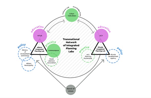
Follow InPlaLabs on Social Media for more information:
- LinkedIn: http://linkedin.com/company/inplalabs-eu/
- YouTube: https://www.youtube.com/results?search_query=inplalabs
- Facebook: https://www.facebook.com/profile.php?id=61559266443050
- Instagram: https://lnkd.in/dNjNHdzg
InPlaLabs Core Educational Team
NTUA Teaching Staff
- Efthimios Bakogiannis - Associate Professor
- Yannis Paraskevopoulos - PhD Researcher
- Stefanos Tsigdinos - PostDoc Researcher
- Ioannis Chatziioannou - PostDoc Researcher
- Anastasia Christaki - PhD Researcher
- Thanos Vlastos - Professor Emeritus
UCY Teaching Staff
- Nadia Charalambous - Associate Professor
- Frixos Petrou - Researcher
- Mariam Shulqamy - Researcher
- Rafaella Christodoulou- Researcher
COMMONSPACE Teaching Staff
- Sofia Tsadari - Architect / Urban and Regional Planner PhD NTUA, Board member of SEPOX
- Dionisia Koutsi - Urban Planner, MSc Environment and Development, PhD NTUA
Urban Calculator Teaching Staff
- Ioanna Stavroulaki - Partner Urban Calculator & Associate Professor, Chalmers University of Technology
- Evgeniya Bobkova - Partner Urban Calculator & PostDoc Researcher, Chalmers University of Technology
- Meta Berghauser Pont - Partner Urban Calculator & Professor, Chalmers University of Technology
Disclaimer: Funded by the European Union. Views and opinions expressed are however those of the author(s) only and do not necessarily reflect those of the European Union or the State Scholarships Foundation (IKY). Neither the European Union nor the granting authority can be held responsible for them.
-
-
InPlaLabs Network Resources
-
-
It contains the following lectures framing InPlaLabs Theoretical Framework:
- Transdisciplinary planning perspectives & principles for the climate-resilient, inclusive, and people-centric city
- The crucial green and digital skills for climate-resilient integrated planning of the contemporary European city
- Mobility planning for addressing climate change and contemporary urban life
- Participatory planning for addressing climate change and contemporary urban life
- Evidence-based planning for addressing climate change and contemporary urban life
-
It contains the following lectures framing InPlaLabs Methodological Resources:
- Quantitative methods for integrated spatial planning I: Connectivity and Proximity Planning
- Quantitative methods for integrated spatial planning II: Centrality and Accessibility Planning
- Qualitative methods for integrated spatial planning
- Participatory methods for integrated spatial planning
- Mixed-methods approaches for climate-resilient integrated planning of the contemporary European city
-
It contains the following lectures framing InPlaLabs Technical Toolkit:
- GIS-based tools and data sources towards climate-resilient integrated planning
- Digital tools for analysing the urban environment I
- Digital tools for analysing the urban environment II
- Tools (digital and physical) for participatory planning
-
Course Description:
During this engaging mini-course, theory on participatory planning meets practice through an engaging workshop simulation. In more detail, this session offers a dynamic exploration of the history, principles, and real-world applications of participatory processes. In addition, an exploration of participatory methods and tools is included, concluding with an interactive workshop simulation.
Keywords: Participation, Stakeholders, Governance, Democracy, Decision-making, Community Engagement
This interactive course offers a coherent overview of the subject of participatory planning and design.
The main points of the course are:- Understanding the historical and political context in which participatory planning began and developed
- Conceptualisation and understanding of the basic principles and methodology of participatory processes
- Presentation of good practices / applied european examples
- Familiarisation with the methods and participatory planning tools
- Workshop simulation
Learning outcomes:
- Creative thinking – Innovations: Inspired by new ideas or combine existing ones to develop innovative, novel solutions for urban issues
- Develop strategies to solve urban problems: Develop specific goals and plans to prioritize, organize and accomplish work
- Interact with different stakeholders: Engage with others face-to-face in a wide range
Who is this course for: This 90 minutes course is suitable for: a) Students with an interest in participatory methodologies in Planning (PhD Candidates, researchers etc.), b) Professionals, policy makers and experts such as urban planners who participate in the design process of city’s public spaces, public buildings, etc.Specific Requirements if any, none.
Information about the course instructors and partners involved:
The instructors are members of the team of COMMONSPACE, which is a collaborative-interdisciplinary planning and design group which has been working on participatory planning since 2012 and has been operated as a Worker Cooperative since 2017. COMMONSPACE provides high quality services in the fields of Spatial Strategies, Architecture, Social Research, Urban and Environmental Design by creating or implementing innovative tools and processes. It seeks to be a link between citizens, social institutions, and public authorities, a hub for the exchange of knowledge, ideas and practices among citizens, experts and decision-makers.
Furthermore, COMMONSPACE has created a specifically structured methodology and a set of tools regarding Multi-Stakeholder Engagement Processes and Participatory Planning.
Instructors´ Names: Sofia Tsadari, Dionisia Koutsi
Instructors´ Institution: Commonspace -
Course Description
Evidence-based Design and Planning (EBDP) is an approach that involves using research and data to inform design decisions. It is a process of collecting and analyzing data to gain insights into user behavior, preferences, and needs, and using that information to guide design decisions. The goal of evidence-based design is to create designs that are effective, efficient, and user-friendly. Examples of evidence that can be used in evidence-based design include user feedback, analytics data, and user research.
Keywords: Evidence-base planning practices, spatial analysis, integration, space syntax, place syntax, GIS, accessibility, connectivity
Key points of the course:
- Theoretical framework and space syntax terms
- Introduction to Space Syntax toolkit and what it measures
- Results: spatial analysis of urban systems using SSx Toolkit in QGIS
- Types of analysis
- Interpreting the results of the spatial analysis: Understand the impact of spatial layouts on various aspects; Testing scenarios; Correlations between spatial values and other forms of data
Learning outcomes:
- Preparing space syntax maps for analysis.
- Running space syntax analysis in QGIS.
- Visualising the results of the analysis
- Running catchment analysis in QGIS.
- Using the SSL toolkit in QGIS
Who is this course for: This 90 minutes course is suitable for: a) Students with an interest in EBDP (PhD Candidates, researchers etc.) b) Professionals and experts such as urban planners who participate in the design process of city’s public spaces, public buildings, etc.
Specific Requirements if any, No GIS expertise is needed, but any basic knowledge of using the Place Syntax Toolkit (PST) will be useful Software Installation: QGIS, PST and SST plugins.
Information about the course instructors and partners involved:
The mini-course is led by the Society and Urban Form (SURF) Research Lab from UCY is a transdisciplinary scientific endeavor focusing on describing and interpreting how the built environment impacts society and on translating evidence from the analysis of urban environments for application in design practice and policy. The mission of the lab is to support the development, design and planning of cities which enable and foster social progress, sustainable practices and healthy habitats by fostering research capacity and excellence in urban design, planning and governance towards understanding and addressing urban challenges, as well as valuing and exploiting opportunities afforded by cities and urban communities.
Instructors’ Names: Mariam Shulqamy, Rafaela Christodoulou, Frixos Petrou, Nadia Charalambous
Instructors’ Institution: University of Cyprus (UCY) -
Evidence-based planning and design: integrating centrality and accessibility analysis into urban design at early stages
Course Description:
Designed to streamline planning procedures, Urban Calculator offers an intuitive interface accessible to planners, irrespective of their GIS proficiency. This tool empowers planners to conduct spatial analyses interactively, enabling informed decision-making supported by robust evidence. In its implementation, Urban Calculator focuses on assessing street centrality, encompassing pedestrian and vehicular street networks. Additionally, it examines accessibility to various destinations, such as social services and bustling urban hubs. The aim of the half day workshop is to introduce the tool to a wider audience, specifically practitioners.
The mini-course objective is to demonstrate to participants how centrality and accessibility analyses can be used as a part of a design loop to quickly measure potential effects of their spatial interventions and to compare different design alternatives.
Keywords: Evidence-base design, spatial analysis, integration, space syntax, centrality, accessibility, accessible density
Course structure:- Lecture on basic concepts of spatial analysis, when it comes to street centrality and accessibility, with the focus on interpretation and understanding analysis results
- Summary of the research background behind selected spatial analyses, in connection to pedestrian movement in cities and socio-economic process
- Demonstration of the tool in connection to evidence-based urban design
- Learning-by-doing design exercise, where participants are asked to test the tool themselves in order to understand the relevance of spatial analysis for early stages of design process
Learning outcomes:
- Being able to interpret space syntax centrality and accessibility analysis in connection to applied urban design,
- Integrating spatial analysis into evidence-based urban design
Who is this course for:
This course is suitable for:
- Students with an interest in EBDP (PhD Candidates, researchers etc.)
- Professionals and experts such as urban planners who participate in the design process of city’s public spaces, public buildings, etc.
Specific Requirements, if any: Windows computers (UC is not supported by Mac), GIS expertise is not needed.
Information about the course instructors and partner involved:
This mini-course is led by Urban calculator which is a research-based start-up and a spin-off from Spatial Morphology research group at Chalmers University, Sweden. Urban Calculator, develops and disseminates Urban Calculator (UC); a design-support software that makes advanced spatial analyses accessible for everyone active in urban development. Urban Calculator allows urban practitioners without prior knowledge of spatial analysis digital tools or GIS (Geographic Information Systems) to learn and integrate spatial analysis to their daily practice, making it part of their design process. Targeting main reasons why practitioners do not use analysis tools and analytic evidence in the design and decision-making process (i.e., no prior knowledge, limited data, time, and resources) the software aims to promote and facilitate evidence-based design and planning in practice, with a specific focus on planning walkable and livable cities in line with Goal 11 (Sustainable Cities and Communities) of the Sustainable Development Agenda 2030.
Instructor´s Name: Ioanna (Gianna) Stavroulaki, Meta Berghauser Pont, Evgeniya (Jane) Bobkova
Instructor´s Institution: Urban Calculator -
Course Description
This interactive course on integrated planning tools provides a comprehensive introduction to planning tools that are essential for analyzing, understanding, and changing cities from both urban and transport perspectives. In particular, the course focuses on leveraging open datasets, spatial analysis and scenario planning to formulate the foundation for effective spatial planning. Participants will be introduced to a variety of tools that facilitate a comprehensive approach, ensuring that transport and land use are seamlessly integrated. Moreover, the course will shed light on how to formulate integrated planning strategies through diverse scenarios that define different priorities, planning and design solutions.
The course’s objective is to bridge the gap between integrated planning theoretical principles and practice, through demonstrating to participants key tools for employing cohesive integrated planning solutions and strategies.
Keywords: integrated urbanism-mobility planning, Open data, spatial analysis, space syntax, typomorphology, Proximity planning, connectivity planning, participatory planning game
Mini-course key-points:- Revisiting key integrated planning principles and implications
- Lecture on the basic concepts and characteristics of planning tools and the importance of open datasets
- Brief lecture on strategic scenario planning to support participants envision creative solutions
- Demonstration of multiple planning tools and strategies with real-life examples
- Hands-on practice, where participants will be requested to formulate their scenarios and deal with a real case study (of their preference) in Europe through an integrated planning perspective. This will help them to acquire significant practical experience.
Learning outcomes: By the end of this mini-course on integrated planning tools, the following learning outcomes are expected:
- Understand the options for pan-European open data which are relevant to integrated spatial planning tools
- Formulate strategic scenarios underpinned with integrated perspectives
- Creative thinking to planning solutions and practices
- Understand how theory could be “translated” into practice
- Teamwork and interaction with individuals coming from different disciplines and background
- Administer urban complexity
Who is this course for: The interactive course on integrated planning is suitable for:
- Students and academics with a keen interest in urban planning, transport systems and environmental sustainability
- Professional and experts dealing with urban, transport and environmental topics
- Policymakers and local administration authorities
- Other actors (such as NGO, groups, collectives) that might aspire to engage in strategic planning
Specific requirements, if any: The participants should have basic prior knowledge of Geographic Information Systems principles and software Furthermore, familiarity with statistics and simple analysis procedures will be a considerable asset.
Information about the course instructors and partners involved:
This mini-course is led by the Department of Geography and Regional Planning of NTUA, and the Sustainable mobility Unit which has adopted an interdisciplinary approach specialising in multiple research fields. Specifically, the main research interests of SMU are urban planning, transport planning, sustainable mobility, urban and transport geography, transport policy and participatory planning. It should be underlined that SMU has embraced an integrated urban and transport planning rationale capable of facing urban complexity and emerging issues.
Instructors´ Names: Yannis Paraskevopoulos, Stefanos Tsigdinos, Ioannis Chatziioannou
Instructors´ Institution: National Technical University of AthensAcknowledgement: This mini-course translates PhD research conducted at NTUA into a participatory action-learning planning exercise for integrated urbanism–mobility planning (Paraskevopoulos & Bakogiannis, 2022; Paraskevopoulos et al., 2022; Paraskevopoulos et al., 2024)